Yesterday, it was announced that the remains of early New Yorkers had been unearthed…under a bus depot in Harlem.
In the earliest days on New York City, before Uber, the Empire State Building, the subway, and the tourists in Times Square… Before it was even called New York City, there were three groups of people living here. First, there were the Native Americans (predominantly Lenape and Manahatta). Then came the Dutch who settled New Amsterdam, which most American middle school students have read about. Then came New Harlem.
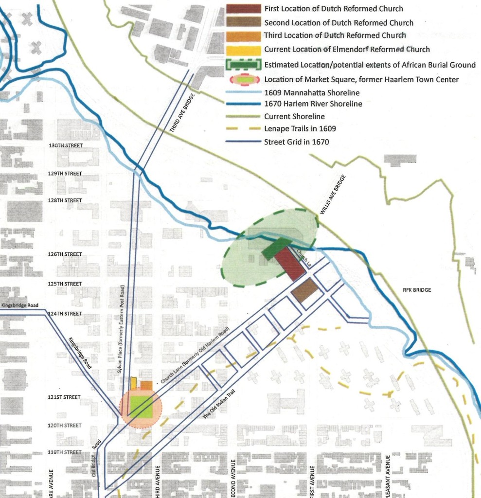
Historical evidence suggests that New Harlem was originally settled by the Dutch in the early 1600s. The Dutch Governor Peter Stuyvesant (you may have heard of him) acknowledged New Harlem in 1658 and the settlement later incorporated into a town and established a Dutch church. There were reports of white Europeans as well as both free and enslaved African Americans living there. A quarter acre burial plot around present-day 1st Avenue and 126/127th Streets was set aside as a “Negro Burying Ground” in 1665. A lot of history happens, but eventually the New Harlem settlement was paved over in 1811 when NYC first instituted the grid plan.
Fast forward to 2011. Many community leaders, such as the amazing Reverend Dr. Patricia Singletary, had been advocating that the New Harlem African Burial Ground from the second settlement of NYC still existed somewhere in East Harlem. Simultaneously, a group of Hunter College Urban Planning students who were trying to graduate wound up working for the Harlem African Burial Ground Task Force. I happened to be part of that group (props to my incredible fellow alumni).
We worked on a lot of different issues in putting a plan together for the memorialization of the Harlem African Burial Ground, and I don’t want to discredit all of the work we put in on a variety of topics. I do want to focus on a map that I made with Erin Congdon and Dan Competillo. Using other historic maps of the area, noting the changes in the topography of Manhattan island over time, and trying to pinpoint a few points we believed may line up with the current grid we map a map of where we believed the burial ground might be:

Map situating the African Burial Ground in Harlem. Credits: Hunter College Report for the Harlem African Burial Ground Task Force. Map by Erin Congdon, Dan Competillo, and Zac Campbell.
Yesterday’s discovery of remains is a great development for the Task Force, and likely for the city, though I’m not sure what it means for East Harlem yet. The burial ground is likely under a variety of existing structures, including local streets, the Willis Avenue Bridge, the FDR highway, people’s homes and an MTA bus depot. It’s great for our history as New Yorkers that we are acknowledging the burial of second settlement here in a public way. But I hope it doesn’t become the kind of memorial that the lower Manhattan African Burial Ground is. I’m also skeptical of the notion of building condos around the memorial that the NY Times article alludes to. This could be an opportunity to address a historic part of New York City that carries some very serious social issues (I remember visiting the site for the first time and people trying to sell me crack on Park Avenue).
I’m very proud to have played a small role in the process of memorializing the Harlem African Burial Ground. I’m also very proud of the work and effort that our team put into the our plan for the area. It is a strange feeling though, more than 4 years after the Hunter College team handed over our report to the Task Force, that suddenly an article in the news appears. In some ways I had forgotten all of the work we did, but I can’t imagine what it must feel like for those who waited even longer.
Many things come full circle, but it’s nice to see that not all things are permanently forgotten in the never ending push towards progress. Still, I wonder what the memorial will look like and what it will mean for the people who live there now.
.
Zac Campbell, a TBQ Contributor, is a New York native and an urban planner. He’s always looking for a map to draw and a passing shot on the tennis court. He blogs at crimesagainsturbanity.nyc, which is where this post first appeared.
